 |
Your SCUBA Diving
Gateway to Lake Tahoe! |
Dive Site Description
Click picture for larger image - Back button to return
|
|
  Sand Harbor Map (PDF) |
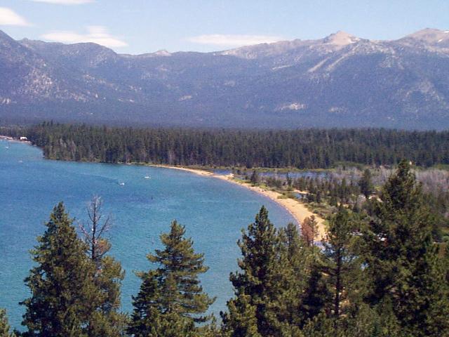
Sand Harbor State
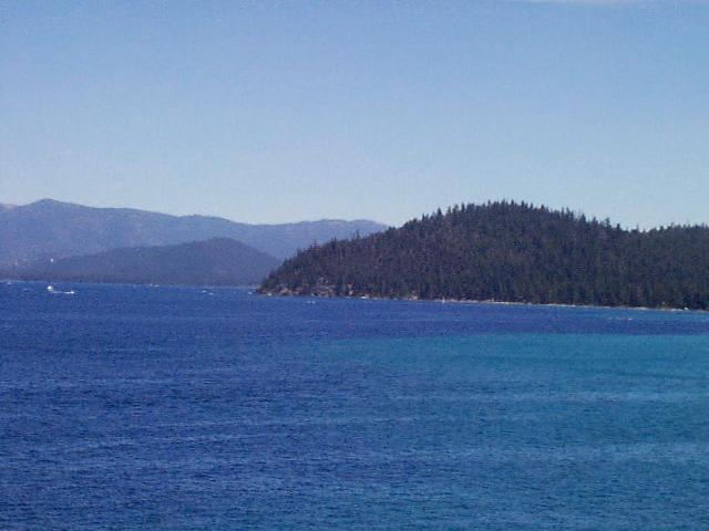
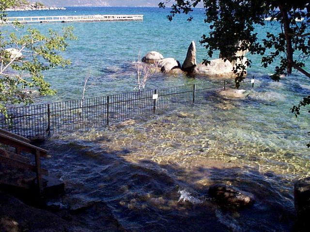
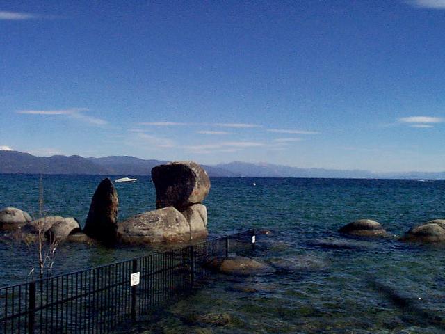
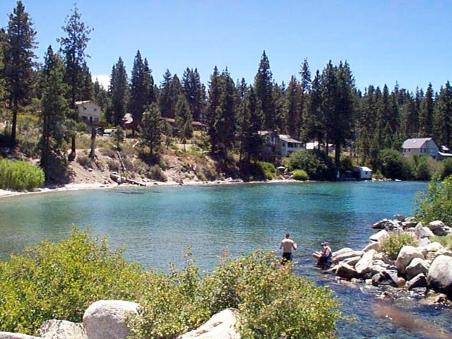
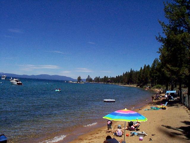
Park Sand Harbor is located at Sand Harbor State Park, 5 miles south of Incline Village, Nevada, on Highway 28. Sand Harbor has an elevation of 6,230 feet and is the most popular dive site in the Sierra Nevada Mountains. In 1958, Sand Harbor was named as the first state park on the Nevada shore of Lake Tahoe. It was named after the sandy beaches located in the area. This is a popular dive site for open-water classes held by many local dive stores. Be sure to pay the $10.00/$15.00 entrance fee, as violators are issued a $90 citation by park rangers. Expect large crowds especially on the weekends during summer months. Diver's Cove, as it is appropriately named, is located 50 yards to the right of the parking lot. The Sand Harbor area has many picnic tables, plenty of parking during the summer months, and clean restrooms. There are two public telephones at this site, one at the south end of the beach and the other located at the boat launching facility. In case of emergency, a telephone located inside the ranger's office at the entrance can be used. The bottom depth averages 30 feet. Those interested in more of a challenge will have to swim 300 feet beyond the swim marker buoys. There is a challenging slope ranging from 40 to hundreds of feet deep. This slope offers vertical cliffs, large sunken trees, and numerous rocks. Boats frequent the area beyond the marker buoys, often traveling at high speeds. Use caution when surfacing in this area. Also keep in mind, that Nevada State Law REQUIRES divers to tow a dive flag. Novice divers will enjoy the many large rocks on the left and right side of Diver's Cove. Approximately 100 feet from shore, at a compass heading of 275 degrees true yields pieces of an old barge. On the right side of Diver's Cove, large granite rocks form a cave. Bottom composition is sandy, with many large rocks to swim around. Visibility can range from 50 to 60 feet.
|
|
|
|
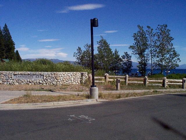  Carnelian Bay Map (PDF) |
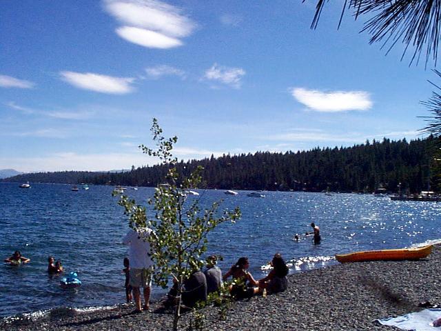
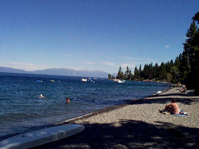
Carnelian Bay Patton Beach is located in the small community of Carnelian Bay. It is 3 miles west of the intersection of Highways 267 and 28, along Tahoe's north shore. Carnelian Bay (Patton Beach) was named by a survey party in 1860, after the semi-precious stones called "carnelian" were found along the shoreline. Carnelian stones are part of the chalcedony group and are composed primarily of quartz. The colors of this translucent stone vary from milky or grayish to a reddish type. The stones are used to make many types of jewelry. Parking is available in the large open lot. Picnic tables and barbecues are scattered throughout. There are porta-potties available during summer months. A grocery store, pizza restaurant, and telephone are located across the highway. This is convenient for any last-minute munchies or supplies left at home. This site is free and the most popular for summer night dives. Many local dive stores conduct night dives here as part of their certification training. The entry is through small rocks, leading into a sandy bottom composition the further one gets from shore. Shallow depths abound for about the first 1,000 feet. The area beyond should be reserved for more experienced divers. Familiarity with compass navigation is a must. Visibility ranges from 50 to 60 feet with an average depth of 20 to 25 feet. Many interesting objects are here, including old motor blocks, deteriorated fishing boats, large submerged logs, and a sunken barge. Numerous crawdads and rainbow trout frequent this area. Night divers can experience many crawdads, fish, and bottom sculpins normally not seen during daylight hours. There are changes in the bottom composition, ranging from sand to a series of rock-ledge steps with small canyons in between. This site is recommended for those recently certified.
|
|
|
|
  Sunnyside Map (PDF) |
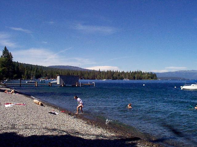
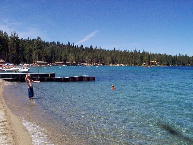
Sunnyside (Kent State Park) Sunnyside, California, is a popular deep and night dive site. Sunnyside is located 2.2 miles south of the Truckee River bridge at Tahoe City, California, on Highway 89. The William Kent Campground is located across the highway from the Sunnyside Marina & Inn. Sunnyside was named by Mrs. Hayes in the early 1880's. Sunnyside is frequently used by dive schools to train divers for deep and night diving. It is not unusual to see classes here on weekends. It is advisable to arrive early as parking is limited. Access to the beach is just a short walk through the fir trees. The beach consists of small pebbles and a little sand. Restrooms are located at the day use picnic area. There is a telephone at the deli, which is across the street to the west. The Sunnyside Restaurant and Lodge is located on the right side of the beach, where refreshments and a good meal are available after a dive. Nothing beats enjoying a sandwich at one of the many picnic tables. After a short 40-foot surface swim from shore, the bottom has a steep drop-off, starting at around 60 feet deep at a 450 angle. Bottom composition varies from a mixture of pebbles to a light-silt. Many logs are scattered along the slope. Visibility can range from 60 to 70 feet. This is a boat mooring area, so caution is suggested. Be on the lookout for larger boats in the area. It is important to exit as close as possible to shore. Large schools of Tahoe sucker fish can be found here, and range in size from 12 to 18 inches in length. This is one of the few areas Lake Tahoe Suckers have been found
|
|
|
 Rubicon Map (PDF) |
Rubicon Point (D.L.
Bliss State Park) D.L. Bliss State Park is located just north of Emerald Bay off High way 89, on the southwest side of Lake Tahoe. D. L. Bliss State Park is closed during winter months, so diving is limited to predictable weather. Rubicon Point was named in 1876 by Lieutenant. M. M. Macomb. The name was taken from the Rubicon River, which is the ancient boundary between Cisalpine Gaul and Italy. Julius Caesar crossed this river to attack Pompeii in 49 B.C. Thus the phrase "to cross the Rubicon" means to commit oneself irrevocably. This phrase applies well to divers making a deep wall dive at Rubicon Point. Currently, a $10.00 fee is charged to enter the park. A campground is located here, making Rubicon Point an excellent overnight dive destination. It is advisable to arrive by at least 9 a.m. as there are limited day use parking spaces. Upon entering the park, there is a "Y" in the road. Proceed to the right towards Calawee Cove Beach. There are long stairs to access the beach. Picnic tables and clean restrooms are located strategically throughout the park. A telephone is located at the park entrance. This site is recommended for all levels of divers. There are diverse areas of shallow to deep water. A wall dive is located at Rubicon Point. This is considered by many as the most breathtaking dive site in the entire Sierra. Since this is a challenging dive, it is recommended only for ADVANCED divers. Vertical drops extend to well over 800 feet and proper buoyancy control is imperative. The Rubicon Point wall is located south of Calawee Beach after a 150-yard surface swim to the right. It is also accessible by boat, eliminating the rigors of surface swimming. Visibility is excellent at Rubicon Point and can range from 70 to 100 feet at a 100 foot depth! There are interesting granite formations consisting of large boulders near the wall. Often, there are large schools of fingerling trout, numbering in the thousands, around the rocks in the 30 to 35-foot range. There have been reports of bears sighted in the morning hours, confirmed by local rangers. However, the sightings have not escalated to anyone being injured.
|
|
|
|
  Hurricane Bay Map (PDF) |
Hurricane Bay Hurricane Beach is an excellent site for deep or night diving. Located 1.4 miles south of Sunnyside, Hurricane Beach covers a half-mile of shoreline. Parking is along wooden posts located next to the bike path. Be courteous to others by not parking on the bike path itself. Look both ways while crossing on foot, as there are daredevil bikers sometimes zooming through here. There is no fee to park here. The lake is approximately 50 feet from the parking area along Highway 89. The drop-off is immediate upon entering the water. This makes the site enjoyable, as there is no long surface swim. The bottom composition is soft silt, sand, and occasional small rocks. Visibility is about 70 feet. Large trees are located on the bottom, starting at depths of 40 to 100 feet. The beach composition consists of small pebbles, and picnic tables outline the beach area. Restrooms are located at the south end of the bay. To encourage safe diving, it is advisable to enter and exit close to the beach as this is a high boat traffic area.
|
|
|
|
   Bucks Beach Map (PDF) |
Bucks Beach On Lake Tahoe's north shore, 100 feet west of the state-line border on the California side, is a small hidden beach located near the city of Brockway. To locate this unique little (and we mean little) beach, head towards the lake on Harbor Street and continue onto Lake Street. The trailhead begins at this intersection. Parking is very limited, as this is a residential area. The best parking is along the private wooden fence leading down to the entrance. Most of this beach is private property, but is well marked with signs on the wooden fence on the east. A word of advice is to arrive early. Otherwise, the walking distance can exceed 300 feet. The remaining distance to the beach is accessible by wooden steps. This is a shallow area, with rocks rising to the surface as far as 500 feet out. This is also a popular night dive site. There are porta-potties near the beach during summer months. The nearest other facilities are restrooms located at the Cal-Neva Lodge. The entry point for Speedboat is a rather narrow sandy beach, consisting of large boulders along the shoreline. Maximum depth is only 20 feet, but the bottom composition is the most interesting in Tahoe. It consists of large, flat granite with many round "craters" throughout. There is no other part of the lake that compares to this. A diving adventure can take you 1,500 feet from shore while you only reach a maximum depth of 20 feet. At a greater distance, there is a marker buoy indicating the abyss and warning boats of shallow water and rocks. It is possible to make the Stateline Wall dive (see Stateline Wall) from Speedboat Beach. |
|
|
|
   Cave Rock Map (PDF) |
Cave Rock Cave Rock State Park is located on the southeast shoreline of Lake Tahoe. The exit is off Highway 50, where the parking entrance is accessible from the highway. The Cave Rock site is held sacred by the Washoe Indians. Divers visiting this site are requested to show respect by not damaging, littering, or removing any objects of historical importance. A $7.00 to $12.00 fee is charged to park and for boat launching. The diving is spectacular and well worth the minimal fee. Amenities at Cave Rock include restrooms and a nearby telephone in case of emergency. The depth reaches 30 feet out as far out as the red marker buoy. Descending at the buoy, one can find an artificial reef. Expect to see lake trout and many crawdads here. Access to the water is easy from the south end of the parking lot. Bottom composition is sand with large scattered rocks. The visibility is excellent, ranging 60 to 70 feet. This site is an excellent year-round dive site for divers of all abilities. One word of caution is to look for boats as this is a boat launch area, sometimes with heavy boat traffic. Nevada State Law REQUIRES divers to tow a diver's flag. Diving without the flag is subject to receiving a citation.
|
|
|
|
  |
Emerald Bay Emerald Bay diving is only accessible by boat. Emerald Bay is located south of Rubicon Point and is by far one of the most beautiful sights to see around the lake. From the overlook on Highway 89, the emerald-green water is comparable to that of a tropical island. The closest boat launch facility is located at Meeks Bay. There is a short 20-minute boat ride to the Emerald Bay dive site. It is advisable to securely anchor your boat or beach it on the sand if possible. Currents here caused by careless speeding boaters make mooring at the island all but impossible. A good beach dive is on the north side of the bay. Here, the water descends to about 20 feet and then onward to the depths. On a nice summer day, this is a great place to beach your boat, enjoy a relaxing dive, and have a picnic. There are no amenities, such as restroom facilities or picnic tables, so come prepared. Visibility is excellent at Emerald Bay and can range from 60 to 70 feet on a good day. There are remains of some old cabins that slid down the hill and many large submerged trees. Bottom composition ranges from sand to soft silt, so buoyancy control is important. Emerald Bay Barges on the Indiana University Web Site:
|
|
|
|
  Zephyr Cove Map (PDF) |
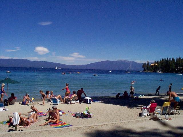
Zephyr Cove Zephyr Cove, is located 4 miles north of the California State border, on the southeast corner of Lake Tahoe. Highway 50 provides access to this site. Zephyr Cove was named for the west winds that blow over Lake Tahoe. The name ~'Zephyr" originated from the Greek God of the west wind, "Zephuros." Zephyr Cove is a very relaxing place to visit due to all the different activities offered. In addition to a good dive site, the diver will find activities such as parasailing, personal watercraft rentals, and the cruise ship M. S. Dixie II located at Zephyr Cove. One may also rent a paddle boat, canoe, or take a sail-cruise on the Woodwind sailboat. There are other amenities, including a gift shop, bar, snack bar, and picnic tables. There is something for everyone here. There currently is a $10.00 to $25.00 fee to park at Zephyr Cove. As you enter Zephyr Cove, turn to the right, leading to the north parking lot. There are plenty of parking, clean restrooms, and picnic tables located near the shore. It is important to stay near the dock pilings at the north border of the beach, for your safety. Zephyr Cove is a heavy boat traffic area, and it is not advisable to dive south of the beach area. Be sure to tow the necessary dive flag, as the dive flag law is strictly enforced here and everywhere else on the Nevada side of Lake Tahoe. After entry from the sandy beach, the water gradually drops off to a flat bottom. The depth is approximately 20 to 25 feet further into the cove. Bottom composition is mostly sand with larger groups of rocks clustered to the north. This is an excellent location for newer divers, but all divers will enjoy the diversity of the ever-changing bottom. Old bottles have been found here, making this a great treasure dive.
|
|
|
|
  Meeks Bay Map (PDF) |
Meeks Bay Meeks Bay is located 5 miles north of Emerald Bay along Highway 89. There is a State Park and public beach as well as a privately-owned area with cabins for rent, picnic tables, campgrounds and a good boat launch area. In addition, there are clean restrooms, a telephone, snacks, and cold drinks. Parking is plentiful, providing easy access to the water. This is the closest boat launch facility to Emerald Bay. It may be closed during drought conditions, due to the water level being too low. The name "Meeks Bay" was derived from the Meeks brothers in 1862, who harvested wild hay which grew there. This resort area is diver-friendly. Currently, there is a $12.00 per day use fee at the resort and a $10.00 per day use fee at the public beach. There is a short 125-foot distance to the waters edge, and an entry point is anywhere along the length of the beach. Upon entry, a short surface swim leads to deeper water. The depth is approximately 10 to 15 feet, gradually extending into deeper water. Bottom composition is sandy with dead trees scattered along the slope. Visibility here can exceed 60 feet on a good day. Heading north, there is a rock ledge at around 60 feet. Often, schools of minnows, whitefish, mackinaw, and many crawdads hiding under large trees can be seen here. Starting at the swim area buoys, just a short surface swim from shore, the bottom drops faster at a 45 angle into the abyss of sand, providing great visibility. The abyss is at a sharp angle, although not considered a wall dive. The two points of rocks on the north and south end of the bay designate the Meeks Bay area. Depending on your point of entry, these rocky points define the changing bottom composition. The resort area is closed during winter months. The beach area remains open to the public, accessible by boat. Parking is limited outside the resort along the highway. It takes more of an effort to get here when closed, but worth it if the weather is moderate. This is an excellent family-oriented diving site. Plan on spending a nice day after diving, by enjoying a picnic lunch at one of the many picnic tables situated along the beach..
|
|
|
|
  Baldwin Beach Map (PDF) |
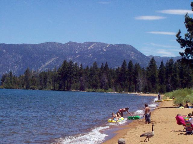
Baldwin Beach Baldwin Beach is located on the southeast shoreline of Lake Tahoe, 2 miles north of Camp Richardson, off Highway 89. This site is patrolled by the U.S. Forest Service (USFS) and a nominal entry fee of $8.00 is charged for parking. After driving past the entrance, there is an intersection where you can turn left or right. Either direction will take you to the area of the beach. Restrooms and parking are only 50 feet from the edge of the water, offering easy access to the dive area. Baldwin Beach is 1.5 miles in length, and diving can be found all along the beach. Amenities include picnic tables and barbecue sites located near the parking lot. While diving here it is advisable to tow a diver's flag, making others aware of your presence and avoiding a citation. Bottom composition is loose sand, and visibility seems to be less than other sites around the lake. This is primarily due to Tallac Creek running into the lake nearby. Visibility in some instances is less than 30 feet, making it less than Tahoe's standard. Upon entry, divers will find a long 800-foot expanse of sand after the beach, before encountering deeper water. From this area, the bottom begins to descend to the abyss at a 350 angle. The main attraction at Baldwin Beach is the submerged trees. Trees as old as 6,400 years have been found, making this a very unique site. These trees may be found at depths ranging from 12 to 20 feet, dispersed in a random pattern along the beachfront. Ongoing research is presently being conducted, by Dr. Susan Lindstrom and the Desert Research Institute (DRI) of Reno, Nevada. The purpose is to gain additional knowledge about the appearance of the lake during early times.
|
|
 |
Stateline Wall The wall at Stateline is the second best wall dive found at Lake Tahoe. The wall site is located directly behind the Cal-Neva Lodge and Casino. The point of the wall is to the west of Crystal Bay. The Stateline Wall is composed of giant granite boulders stacked on top of each other, forming a wall. The depth drops to over 800 feet. Visibility here is usually 80 feet or greater, depending on the time of year. The Stateline Wall offers a great thrill worth experiencing. A word of caution is in order. This is an advanced dive, recommended only for experienced divers. Buoyancy and air control here are a must. This is the only site where there is no fee to access a wall dive. The point of entry is from Brockway Beach (see the Brockway Beach dive site). There is a 900-foot surface swim from the east shore to reach the point. The easiest entry point is from the walkway at the parking lot. Here, the water is only 3 feet deep. As you reach the west flank of the wall, the depth begins to increase. At this point, Brockway Beach is out of visible range. A great effort is required to get to Stateline Wall. If you are planning on reaching this site by boat, there is plenty of room on the west, for anchoring a boat, but not much shelter. Also, be careful when anchoring as the bottom composition is soft sand and the anchor tends to easily come loose if not properly set. |
Dive site descriptions courtesy of "Mountain Lake Diving" by Phil Moyer and Keith Nemestka.
![]()
Home Page | Lake Tahoe Diving | The Dive Center | Class Dates | Dive Trip Calendar
Professional & Instructor Training | Equipment
| Specials | The Staff | Related Sites
Sierra Diving Center - 104 E. Grove St - Reno, NV 89502 - (775) 825-2147
All information contained in this site Copyright 1997-2016 Sierra Diving Center
Updated 4 January 2022